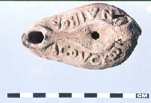
In the winter of 1999-2000, excavations continued in trench 30 which was only partially excavated during the previous season. This trench explored the north-eastern portion of a large structure located on the north-eastern part of the site. During previous seasons, three other trenches have been excavated within this structure: trenches 8, 12 and 22 (trench 30 partly overlaps with trench 22). The goal of trench 30 was to further explore this 5th century structure and to determine its function in the north-eastern quadrant of the town. The building may well be an early Christian ecclesiastic structure as suggested by the lay-out as well as an oil lamp with a Christian inscription (see picture below) and several crosses that were found here.
Trench 39 was opened in the year 2000 in the same large building as trenches 8, 12, 22 and 30. Trench 39 is contiguous with trench 8, lying due east of the earlier trench, and has been set 1 m (3 ft) south of trench 12. The goal of trench 39 is to further explore the 5th century structure, to determine its function and to get information in the earlier use of the area. Theories regarding the function of this structure have varied widely over the previous seasons. However, due to research in five trenches located in this building, it is now possible to have a broader interpretation of its function and history.
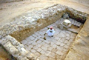
At this point, the building appears to be a single structure devoid of other encroaching buildings. A breeze way or hallway is the central axis dividing the building in half. The northern portion of the structure serves as the domestic sphere of the building, while the southern half serves as the public sphere. Trench 39 is located within this public sphere. Although the private sphere of the household is well documented in both trenches 8 and 30 with the presence of a kitchen, storage rooms and living quarters, the public sphere was not fully understood until the excavation of trench 39. Excavations in trench 39 have revealed the interior portion of a foyer and also a colonnaded courtyard that the foyer grants access. The relationship between this courtyard and room lined with a series of benches found within trench 8 (see previous page) can now be better understood. Also, the function of the grand flagstone floored courtyard and single pillar excavated in trench 22 (see picture below) can now be interpreted. Plans for coming seasons include to fully expose the remaining space between trenches 39 and 22 to investigate the entire public sphere of the structure.
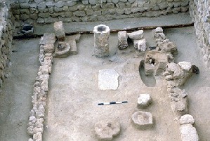
Excavations also continued in trench 32. This is a trench of 3 x 5 m (9 x 15 ft) which was connected with the neighbouring trench 23, revealing a temple (see picture below). A new discovery this season are the remains of wooden bowls in the eastern part of the building, near the doorway. Similar remains, which just survive as brown coloured circles in the soil, were also found in trenches 23, 16 and 10 suggesting the continuation of religious practices for a long period of time (see previous page).
Trench 34 is a 6 x 6.5 m (18 x 20 ft.) trench set out along the east-west running street through the settlement (identified as Decumanus Maximus), from the main temple of Serapis to the Red Sea. This trench is just north of trench 21 (a trash dump excavated in 1998) and east of trenches 20 and 27 which revealed coral buildings. The reason for laying out this trench was the interesting floor plan visible on the surface: a large rectangular structure with a doorway facing south, towards the street, with a possible inner division in the north-eastern part of the building. Excavations unearthed the remains of a staircase, indicating either a second floor or otherwise the extensive use of the roof. Staircases were also found in trenches 37, 38 and 41 which suggests that the Mediterranean pattern of working and business concentrated on the ground floor with residential areas on the top floors was also followed in Berenike. It can be suggested that the trash dump excavated as trench 21 was the disposal area of the people living and working in the building now partly excavated in trench 34.
The dimensions of trench 37 were originally 8 x 4 m (24 x 12 ft) but, as the architecture was being uncovered, it proved necessary to extend the trench 0.6 m (2 ft) towards the north to reveal the complete northern doorway. Later in the season the trench was extended 1,4 m (4 ft) and then another metre (altogether 2.4 m or 7 ft) towards the south in order to excavate the complete room or courtyard with its south wall. The dimensions of the trench thus became 8 x 7 m (24 x 21 ft).
Trench 37 is located in a building which lies on the south side of the so-called Decumanus Maximus, the street that runs through downtown Berenike in an east-west direction from the Serapis temple towards the Red Sea. The building itself lies not more than one city block from the temple area. It is supposed to have had a public function, the nature of which is still unclear since the season was spent clearing collapse from the interior of the northern part of the building. Occupation levels were uncovered, but not yet excavated. The excavated space is putatively interpreted as a courtyard, mainly on the basis of its architectural features. It has two entrances, one in the north, from the street, and one in the south from a yet unexcavated room. Furthermore, it has two staircases, a rather monumental one, leading to the threshold between the northern and the southern room, and another leading to a second floor, or the roof, on top of the southern room.
In this trench three inscribed stones were found, all with texts in Greek (see picture at the top of this page). Two inscriptions, which seemed to have been copies of an identical text, were dedications to Zeus (Jupiter) by a woman named Philotera, probably during the reign of Nero (54-68 AD). The stones were partially defaced during antiquity and re-used as building material. The other inscription was a dedication to Isis during the reign of Trajan (98-117 AD). This stone was also removed from its original position and seemed to be stored for later re-use. The restricted access to the main parts of the building suggests the desire to monitor and probably limit who entered and left. This would have been the case in buildings where important business was conducted, like the trade in valuable commodities or the making of decisions on a municipal or military level.
In order to expand the area of excavation in a substantial 5th century AD building first investigated in 1999, trench 38 was opened immediately east of trench 28. Each trench originally measured 9 x 4 m (27 x 12 ft). Several days before the end of the 2000 campaign, trench 38 was expanded 1 m (3 ft) to the north in order to regularize the effects of a major baulk collapse that exposed two new walls in the north-east quadrant of the trench. However, the collapse could not be excavated stratigraphically. Since trench 38 was not opened until halfway through the season, when only three weeks of the excavation season remained, it was an investment in the future. Its goals were to expose as much of the architectural plan of the building as possible, starting with bringing the new trench into phase with contiguous trench 28. Both goals were successfully achieved and work will continue here next season.
Excavation so far revealed the entire north half of the building. Although the two trenches are not yet completely in phase, their respective stratigraphies can easily be correlated. In trench 38 only the two latest phases in the history of the building were encountered. Phase I (5th century AD architecture) was exposed and phase II (sediment and debris strata from the post-5th century AD abandonment of the building) was excavated. Although excavation did not reach occupation levels in trench 38, architectural debris layers created by the collapse of its phase I walls and features yielded dates wholly consistent with those excavated in trench 28 during the 1999 season. The earliest structural debris strata excavated in trench 38, in the east half of the building, produced pottery from the same period. Like in trenches 34, 37 and 41, a staircase was unearthed in trench 38 indicating the use of the roof or some superstructure.
Trench 41 was positioned approximately 50 m (150 ft) north of the main east-west street through Berenike ('Decumanus Maximus') and just west of the main north-south street through the town. Its position was determined according to the floor plan visible on the surface which formed a roughly rectangular shape suggested a building or room in this area. The immediate goals of this trench were the identification of this structure and its uses, which will not be completed until excavations continue in future seasons. Most of the trench consists of a room with internal dimensions 5.35 m (16 ft) east-west and 2.90 m (9 ft) north-south, with the north-east corner of the room in the north-east corner of the trench. At the end of the excavation season, the walls were exposed to a height of 1 to 1.5 m (3 to 4 ft). The entrance to the room is in the south-west corner. The central room was partly excavated and appeared to have a total of five niches in three of the four walls. These all had a shelf and bottom of decayed wood but were otherwise empty.
Outside the room, along its west wall, a staircase was found, similar to those in trenches 34, 37 and 38. This is again a strong indication of the use of superstructures, probably as residential area, while the ground floor of the building was used for business ot work. This is the prevailing pattern all over the ancient Mediterranean. The long-term goals for the research in this trench include a further understanding of the municipal and economic function of this area of ancient Berenike as well as the possible identification of the shoreline in the Ptolemaic period.
Trench 33 was the fifth trench to be excavated in the
area of the early Roman trash deposit located along the north-west perimeter
of the ancient city. A 5 x 5 m (15 x 15 ft) trench was laid out between
trench 19 to the north and trench 31 to the south. Two other previously
excavated trenches (29 and 13), are situated north-west of trench 33. All
these trenches are located on a slight incline which slopes downward from
the main area of occupation at Berenike, with the datum for trench 33 at
4.48 m (176 in) above sea level. Much of the surface of this area is covered
with a dense scatter of potsherds and rocky debris, and the removal of
a few centimetres (an inch) of soil often reveals trash deposits (see picture
above). The virtual absence of architecture indicates that in the early
Roman period this area was exclusively reserved for trash, which was apparently
piled in heaps still extant on the surface. Excavation also seems to indicate
that deposits tend to follow the natural topography of this area of the
site.
Trench 35 is a 6 x 6 m (18 x 18 ft) trench in the
Ptolemaic area, on the western edge of the site. The trench was put here
to check the results of the magnetometric survey which was done here in
1999. No buildings or occupation phases were found. Trench 36 (6 x 6.5
m or 18 x 20 ft) was also laid out in the south-western part of the site
in order to recover evidence belonging to the Ptolemaic period and to expose
the possible architectural remains identified through the magnetometric
survey. Some poorly built walls and a large amount of partly worked lead,
some of which seemed to have originally been flattened into sheets, were
unearthed. In the north-eastern part of the trench part of some hydraulic
installation was discovered. Though this trench could not be completely
excavated due to lack of time, the excavated area has revealed evidence
mostly datable to the Ptolemaic period. Ceramic specialists dated the large
fragments of amphorae to the Ptolemaic period but were unable to further
refine this. Based on stratigraphic information, the evidence found in
this trench can be assigned to two periods: phase I (Ptolemaic) and phase
II (post-Ptolemaic).
Trench 40 was a third trench in the Ptolemaic area and measured 6 x 7 m (18 x 21 ft). The trench was also put here to check the results of the magnetometric survey which was done last year. Remains of a large, well built wall were found, partly in a rock-cut foundation trench. The side walls shown on the magnetometric survey were robbed out in antiquity. Finds from this trench include a small carved head with a definite Nubian or African appearance and part of a molar of an elephant, the first archaeological evidence for the presence of these animals in Berenike.
Excavations in trench 10 were continued this season as
well. Trench 10 was started in 1996 as a 10 x 10 m (30 x 30 ft) square
at the centre of the site between the temple of Serapis and trench 1. The
purpose of trench 10 is to get a full stratigraphic overview of the site
(see previous
page). During the year 2000, the late Roman walls were recorded in
detail and removed to enable the excavation of earlier levels. Excavations
have now reached early Roman levels. Ptolemaic material was only residual,
but at the end of the season the top of the Ptolemaic habitation levels
were reached.
An important complement to the work at Berenike is
the on-going survey of the desert hinterland. This includes investigation
of the roads leading to the Nile Valley, mines, quarries, desert settlements
and possible Christian anchorite communities in order to record the archaeological
remains of which many are under immediate threat by the development of
the Red Sea coast for tourism.
The fort (hydreuma) of Siket lies approximately 7 km (4 m) north-west of Berenike. The fort most likely holds a well or a large cistern. It has been suggested that Siket, along with the two forts at Kalalat (see text below), provided drinking water for the inhabitants of Berenike. Survey of the area suggested a 1st-3rd century AD date for the structure. The gate area of the fort at Siket was excavated in 2000 with the objective of obtaining reliable dating evidence. The trench measured 4 x 4 m (12 x 12 ft) and was positioned between the two towers guarding the main gate in the north wall of the fort.
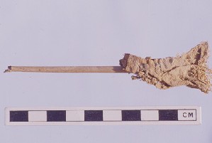
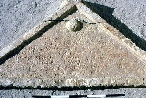
Excavations have revealed a door locking mechanism, monolithic door jambs and a huge triangular freeze, almost 2.5 m (8 ft) long, with an inscription in Latin (see picture above). The text states that the fort was built here as an hydreuma and lists by name the Roman governor to Egypt at that time together with the Roman governor of Berenike. Another name mentioned in the text may be that of the local camp commander. This inscription clearly dates the fort to the 9th year of the reign of Vespasian (67-68 AD).
A trench was also laid out in the gateway of the smaller (26 x 32 m or 78 x 96 ft) fortification in Wadi Kalalat. Since trenches located in the main gateway of both the fort at Siket and the larger fort (hydreuma) in Wadi Kalalat produced an inscription, it was foreseen that also this smaller fort in Kalalat might yield such an inscription to give a precise date. Unfortunately no official building inscription came to light in this trench. The trench was intended to span the entire main gate, in the east wall, of the fort. It was situated between the two gate towers of the fort, a semi-circular tower on the north and a rectilinear, possibly remodelled tower on the south. The trench measured 4 x 6 m (12 x 18 ft). As it turned out, the trench only exposed the north side of the gateway, where the architecture proved to belong to a single period of construction. The putatively two-phase south tower of the gateway lay outside the borders of the trench.
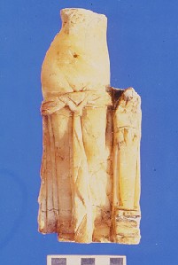
The second Venus of Berenike: