
Season 2010
Introduction
Work in the Fayum started on September 18 and ended December 16, 2010, with a break for the Eid el-Adha from November 12-20. The purpose of the Fayum project is to gain an understanding of the landscape north and east of Lake Qarun and specifically of the land and water use in the Fayum over time in relation to the development of agriculture.
Excavation and Field School in Karanis
The fieldschool was taught from October 2 through November 4 and was closed off with a ceremony at the office of the SCA in Zamalek with the presentation of the certificate and a wonderful speech by Dr. Sabry Abdel-Aziz. This year's students showed to be fast learners, and several of the students can be considered sufficiently advanced to run their own trenches, including all the paperwork and writing the report.
Summary of the trenches:
Work continued in the Northeast area of the site, where no excavations have taken place before 2008. Eight new trenches were laid out and partially excavated (Figure 1). Trench 25 covered part of the same house as trenches 11, 15 (started in 2008) and 18 (started in 2009). Trench 25 also included the neighboring alleyway.
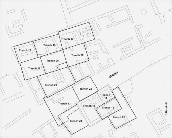
Figure 1: Trenches excavated in 2010 in the northeast area of the site. Trenches 11, 15, 18 and 25 together cover house N1. Trench 23 is the next door house to the west. Trench 22 is the eastern extension of trench 13 in the street. Trench 21, 26 and 27 are the new trenches in the thesauros (previously excavated in trenches 12, 17, 19 and 20. Drawing by Hans Barnard.
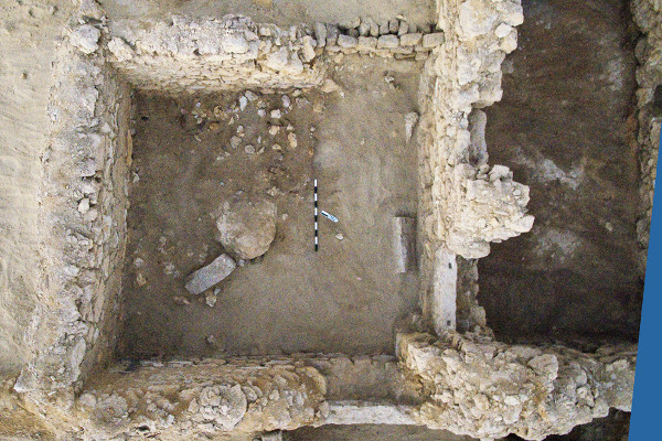
Figure 2a: Trench KA25 in house N1. Photograph by Joseph Lehner
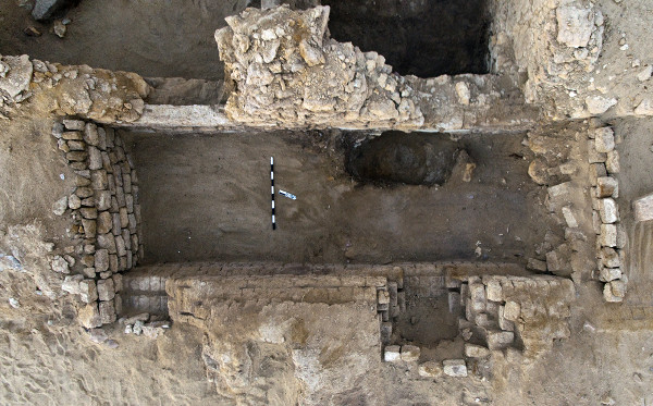
Figure 2b: Trench KA25 in house N1. Photograph by Joseph Lehner
Trench KA25 included the alleyway with two street entrances into house N1 (Figure 2). Most of this house was excavated in 2008 and 2009 (trenches KA 11, 15 and 18). The house was badly robbed out, but showed that it was built after the neighboring structure immediately to the south. Ceramics found in the structure indicated that the first building phase should probably be dated to the fourth century CE, over earlier remains, possibly of an early Roman garbage deposit area.
To the west of house N1 a mud brick structure was excavated (Trench KA 23, see Figure 3a-c). From the fact that the east wall of this house, which was immediately adjacent to the west wall of house N1, was only two bricks wide, and followed the curves of the stone foundation walls of N1, it is clear that this structure was built after the first phase of N1 had been built. The west wall of the mud brick house is much more substantial. The house is built on the lime stone bedrock, but must have been established when the street level outside had already risen substantially: two mud brick steps lead up from the room to the wooden threshold. The wall in which the front door was built rested upon a very thick layer of dark grey mortar, which seems to have been deposited as a leveling fill, but was not spread out over the adjacent uneven bedrock. In most of the house the floors were robbed out, and rubbish which could be dated to the 1940s was found at quite deep levels. From the plaster edges it is, however, still possible to reconstruct some of the original floor levels.
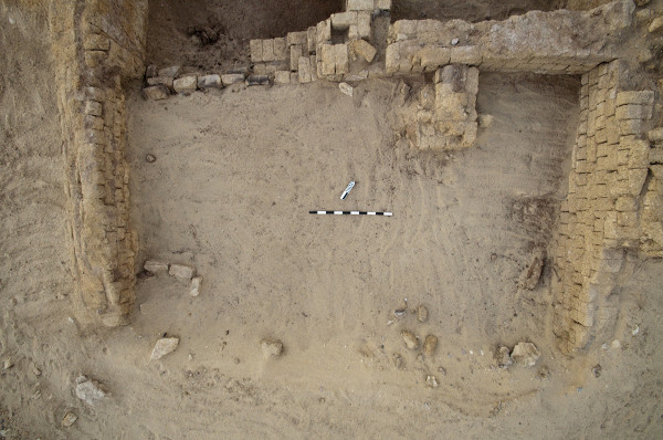
Figure 3a: Trench KA 23. Sundried brick house. Photograph by Joseph Lehner.
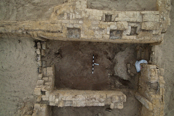
Figure 3b: Trench KA 23. Sundried brick house. Photograph by Joseph Lehner.
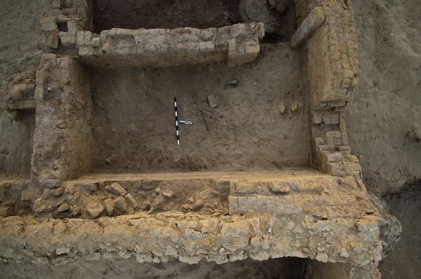
Figure 3c: Trench KA 23. Sundried brick house. Photograph by Joseph Lehner.
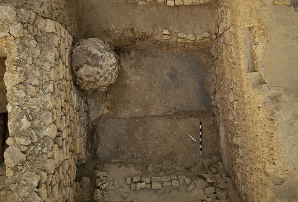
Figure 4: Trench KA 22, the street between the thesauros and house N1. Photograph by Joseph Lehner.
An extension was dug immediately to the north of the street trench KA 13, and named KA 22. The purpose of this trench was to establish the relation between house N1 and the thesauros, or storage building. The most striking feature was the presence of a large coarse limestone circular block, which sat in the street at a very low level, but seemed not to be attached to the bedrock. This is one of the roughly circular hard limestone shapes that have eroded out of the softer surrounding limestone and occur in natural bands throughout the landscape. The part of the rock adjacent to the north wall of house N1 was actually cut away to allow the building of this wall. Intact street layers showed that the layers found inside trenches KA 11 and 15 continued in the street. It also clarified the temporal relation between the house and the granary. The foundations of the latter were built before the outer walls of house N1 were established. The limestone thesauros foundation shows, however, three distinct wall sections, with the middle section perhaps an infill of two earlier buildings. The subsequent sun dried brick layers of the upper walls formed a continuous fabric and were built in one phase.
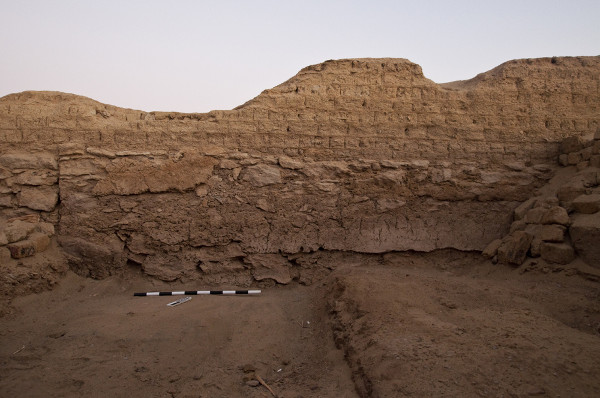
Figure 5: South wall of the thesauros with two layers of plaster covering the stone foundation. Photograph by Joseph Lehner.
Excavation of the entrance of the thesauros and the rooms immediately to the north and east of it (Trench 21), revealed an earlier phase internal doorway, lined with nicely cut limestone revetting, which was subsequently blocked. During the major use phase of the granary the entrance of the storage room was tightly controlled. Users entered through the L-shaped wall in the street, passing a substantial door, then entered the first room in which they had to turn right into the stairwell, and then through another door at the top of the first flight of steps in order to reach the main storage area with the entrances to the binned rooms and underground vaulted rooms. The courtyard has several underground vaulted rooms which can be reached through hatches in the floor. In the eastern part of the courtyard (Trench 20, excavated in 2009) the vaults have openings at the top, lined with reused necks of amphoras. In the western part of the courtyard (Trench 26) the vaults are completely closed. One vault had an intact wooden hatch and contained a large amount of undisturbed botanical materials, among which a large amount of safflower, used for oil production. During a second phase one of the bins was taken out of use, and an opening was made to create a direct connection with the entrance hall of the storage room (Trench 27).
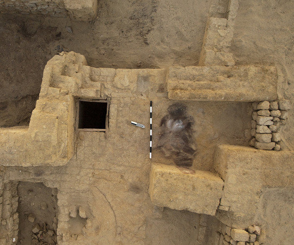
Figure 6a: Entry way into the Thesauros. Photograph by Joseph Lehner.
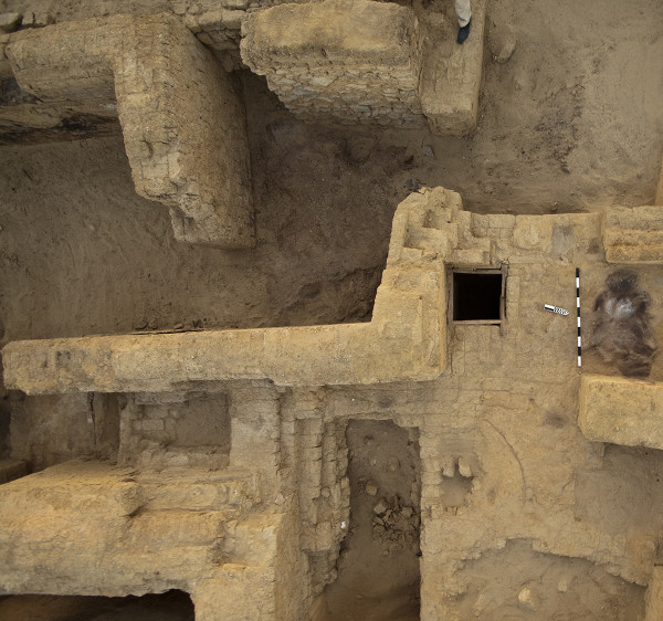
Figure 6b: Entry way into the Thesauros. Photograph by Joseph Lehner.
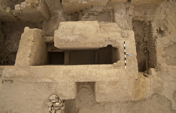
Figure 6c: Entry way into the Thesauros. Photograph by Joseph Lehner.
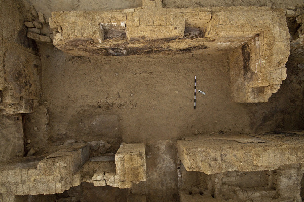
Figure 6d: Entry way into the Thesauros. Photograph by Joseph Lehner.
At the top of the site, near Michigan's "Area G" work continued in Trench KA 14, and a new adjacent trench in the same building, Trench KA 24. The latter was a staircase and an intact vaulted room. At 2.50 m deep, excavating through clean wind blown sand, a newspaper was found which announced the death of the sister of Lord Kitchener. Although the newspaper did not contain a year, it is clear that this area has been excavated in the 1930's. Another reason to halt deeper excavation in the stair case, and start excavation in the vaulted room is that the entire building in which trenches 4 (courtyard), 14 (threshold and inner room) and 24 (staircase and vaulted room) are located has shifted and the walls show a slump towards the south. Excavation in trench 14 continued, and remains of a robbed out floor were found, broken through by collapse and filled with rubble and garbage deposits. A very organic layer which seemed to consist of pure threshing remains had subsequently been robbed out, but could still be sampled for analysis around the edges of the room, which still held some of the deposit.
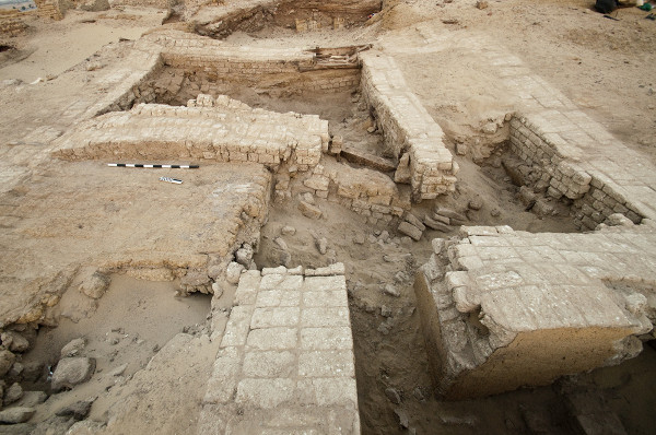
Figure 7: Trenches KA 4/14/24. Photograph by Joseph Lehner.
Monitoring Threat at el-Qarah el-Hamra
In October 2010 we visited the Greco-Roman site of el-Qarah el-Hamra, to check the preservation of the site. During the field school in 2004 the eastern part of the site was planted with widely spaced olive trees in between which archaeological remains could still be seen on the surface. In 2010 the fields had been plowed, heavily watered, and planted with tomatoes. The western part of the site has seen more damage, due to bulldozer scoops to collect clay for making road surfaces, but most of that part of the town is still intact.
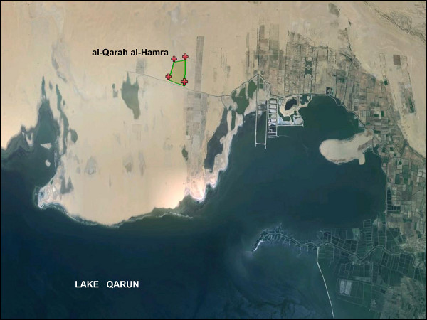
Figure 8: Map showing the location of el-Qarah el-Hamra
Rescue Excavations at Kom W
The 2009 report describes the destruction of the unique prehistoric site of Kom W. Upon our return in 2010 it appeared that the destruction continues with many new robber holes being excavated, one to a depth of 15 meters. Our rescue excavations at Kom W try to record the most important information to be gained from this site, which is the layering and density of Neolithic hearths.
Survey on the North Shore of Lake Qarun
The north shore of Lake Qarun offers the unique possibility to study what in effect is an undisturbed Neolithic landscape. Therefore in 2009 the project started to use a survey strategy which consists of laying out large areas in the form of a plus-sign consisting of two perpendicular 10 meter wide strips of 100 meter long, by 100 meter wide. In these plus-signs every piece of flint, bone, pottery, or ostrich egg shell was measured in with a total station. In between these transects all hearths and grinding stones were mapped out (Figure 9).
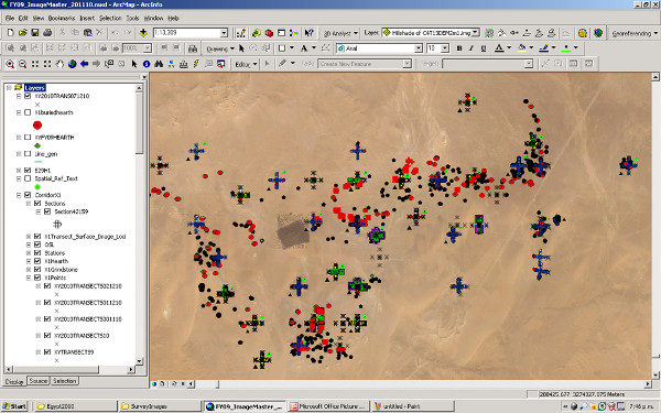
Figure 9: Dense clusters of hearths, grinding stones and artefact scatters recorded in 2010.
Based on these results, other measuring areas were added to augment the picture. It appears that most human activity concentrated in a band of about 200 meters wide along the lake shore, but this is not a continuous stretch. Further analysis and next year's survey should clarify what caused these areas of concentration.
Finds Analysis
The finds are typically modest and fragmentary, as is typical for most settlement sites. The work of the specialists concentrated mostly on the organic find groups. The study of wood, plant remains, basketry, textiles and zoological materials is ongoing. Glass, ceramics and terracotta specialists provide not only dating information, but contribute to map out a range of economic activities, which complement the agricultural emphasis of the project.